Fahmina Binte Ibrahim
FIFahmina Binte Ibrahim
👋 Hello, I'm

Fahmina Binte Ibrahim

Transportation GIS Planner

Ph.D. Student, Geographic Information Science · Texas State University

I work at the intersection of GIScience, disaster science, and GeoAI, with research on flood-responsive evacuation and traffic management, geo-localization of crowdsourced flood imagery, and remote sensing for transportation and environmental applications.

Education

Ph.D.In progress

Geographic Information Science

Texas State University
San Marcos, Texas
Aug 2023 – Present
Advisor: Dr. T. Edwin Chow
M.S.

Disaster Science and Management

University of Dhaka
Dhaka, Bangladesh
Aug 2018 – Jan 2020
B.S.

Disaster Science and Management

University of Dhaka
Dhaka, Bangladesh
Feb 2014 – Aug 2018

Experience

Click a role to see details.

  • Developing a flood-responsive traffic management system that leverages real-time flood monitoring, machine learning, and dynamic lane reversal strategies to optimize evacuation routes and traffic flow.
  • Using GeoAI to enhance geo-localization of crowdsourced flood images through contextual relationship extraction and multi-source imagery analysis for real-time flood monitoring.
  • Contributed to a health-related web application analyzing HIV prevalence in U.S. counties; assisted with spatial analysis and manuscript preparation.
  • Geographic Information System Lab, GEO 5418/7417 (15–20 graduate students).
  • Prepare course lab materials, assist graduate students with GIS labs and projects, and evaluate assignments and lab reports.
  • Worked with the Remote Sensing team in the Design Division on transportation-related geospatial and imagery analysis projects.
  • Assisted with spatial data processing, remote sensing applications, and GIS-based analysis to support transportation planning and infrastructure projects.
  • Conducted GIS-based data analysis for remote sensing projects, calculated deforested areas, and automated settlement mapping using machine learning and deep learning techniques.
  • Geographic Information System Lab (15–20 graduate students).
  • Prepared course lab materials, assisted graduate students with GIS labs and projects, and evaluated assignments and lab reports.

Projects

Ph.D. Dissertation · Ongoing

A Quest to Understand Behavioral Uncertainty, Dynamic Traffic Management, and Adaptive Optimization in Flood Evacuation

An integrated GIS-based flood evacuation framework for the Buffalo Bayou watershed in Houston, Texas, built as three connected papers.

View project →
Ongoing

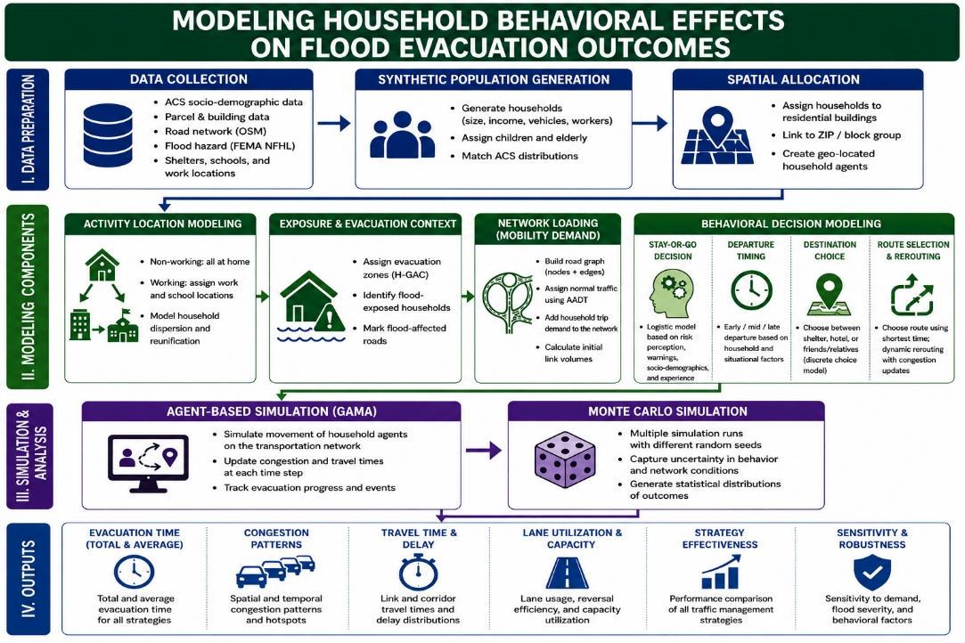
Modeling Household Behavioral Effects on Flood Evacuation Outcomes

This study examines how household evacuation decisions (whether to stay or leave, when to depart, where to go and which route to take) shape evacuation outcomes during urban flooding in Houston’s Buffalo Bayou watershed.

Agent-Based ModelingHuman BehaviorSynthetic PopulationMonte Carlo
📝 Manuscript in preparation · Ph.D. dissertation researchView details →
View project →
Ongoing

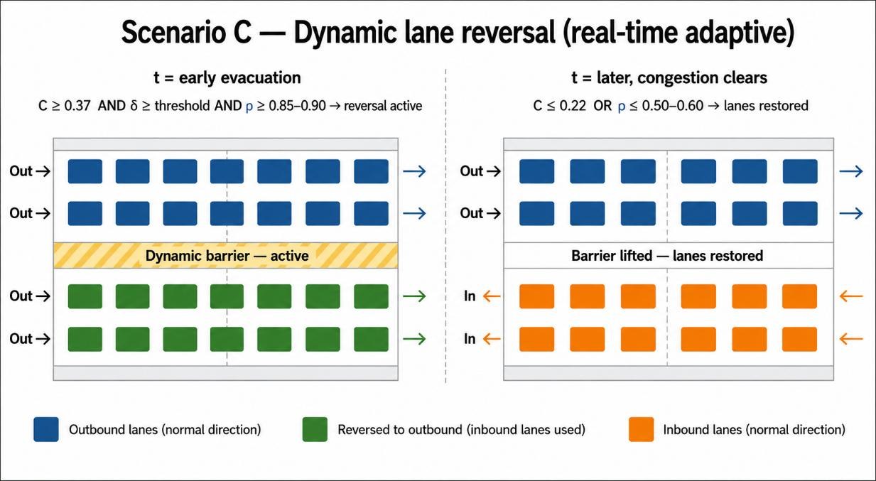
Evaluating Evacuation Efficiency under Flood Conditions and Traffic Management Strategies

This study evaluates how traffic management strategies affect evacuation efficiency as flood conditions evolve, comparing normal operations, a fixed contraflow plan and adaptive dynamic lane reversal.

ContraflowDynamic Lane ReversalTraffic SimulationFlood Exposure
📝 Manuscript in preparation · Ph.D. dissertation researchView details →
View project →
Ongoing

Reinforcement Learning–Based Dynamic Lane Reversal in Flood Evacuation Optimization

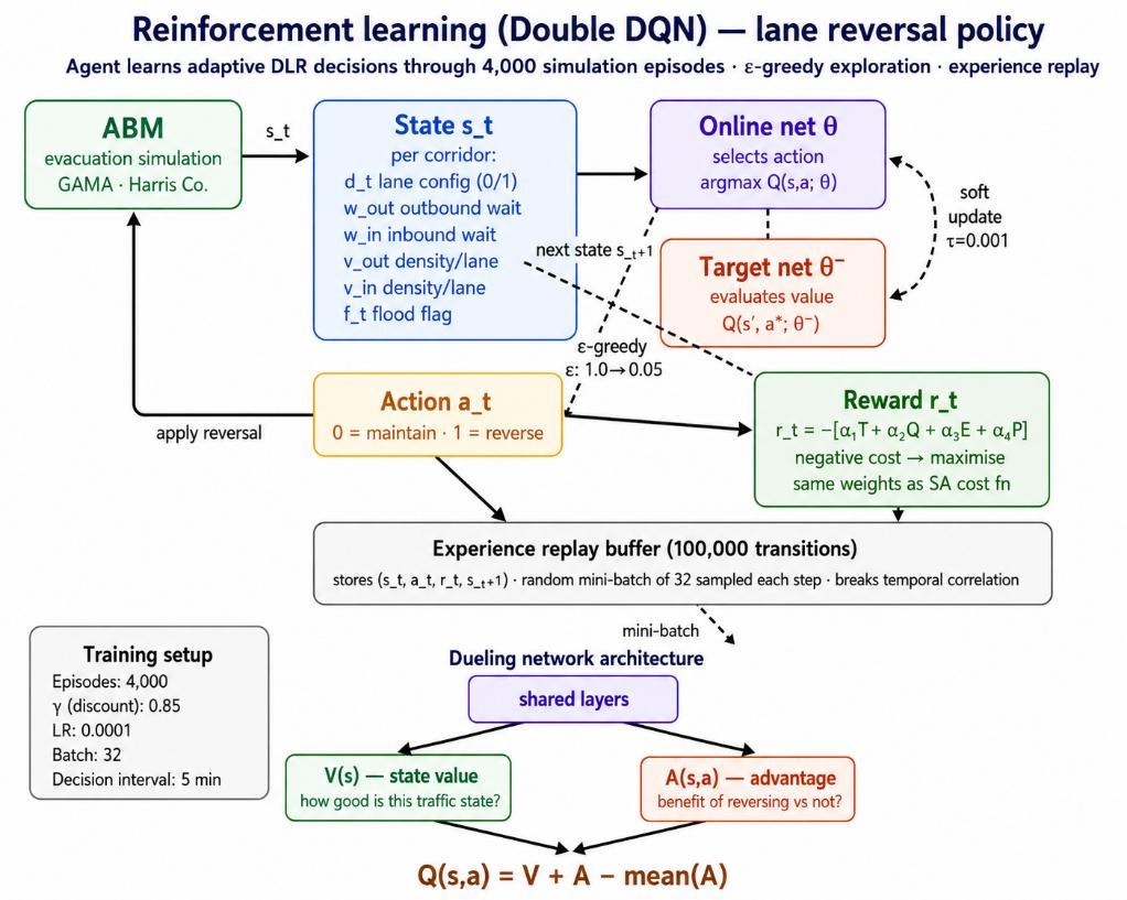
This study investigates how the decision-making method behind dynamic lane reversal influences evacuation performance, comparing rule-based control, simulated annealing and a reinforcement learning agent within the same simulation.

Reinforcement LearningDouble DQNSimulated AnnealingOptimization
📝 Manuscript in preparation · Ph.D. dissertation researchView details →
View project →
Completed

Predictive Analysis of CO₂ Emissions Using a Random Forest Regression Model

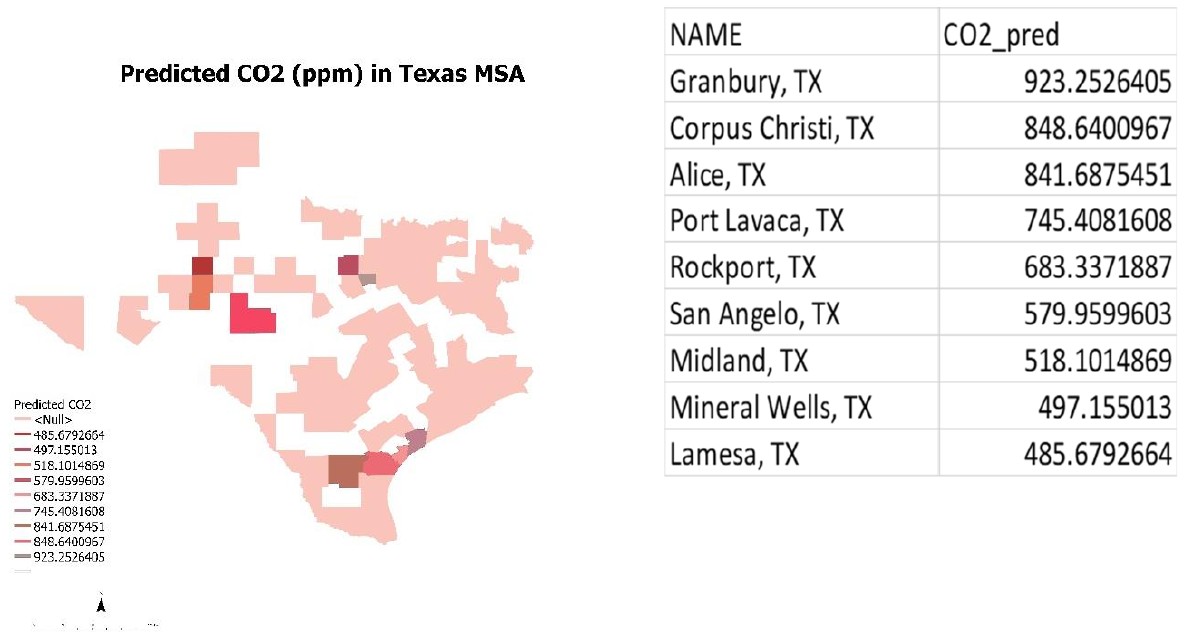
A machine learning approach to predicting carbon dioxide levels across Texas metropolitan statistical areas, linking satellite CO₂ observations to land cover, population and land surface temperature.

Random ForestRRemote SensingLandsat LSTNLCD
🎓 Texas State UniversityView details →
View project →
Completed

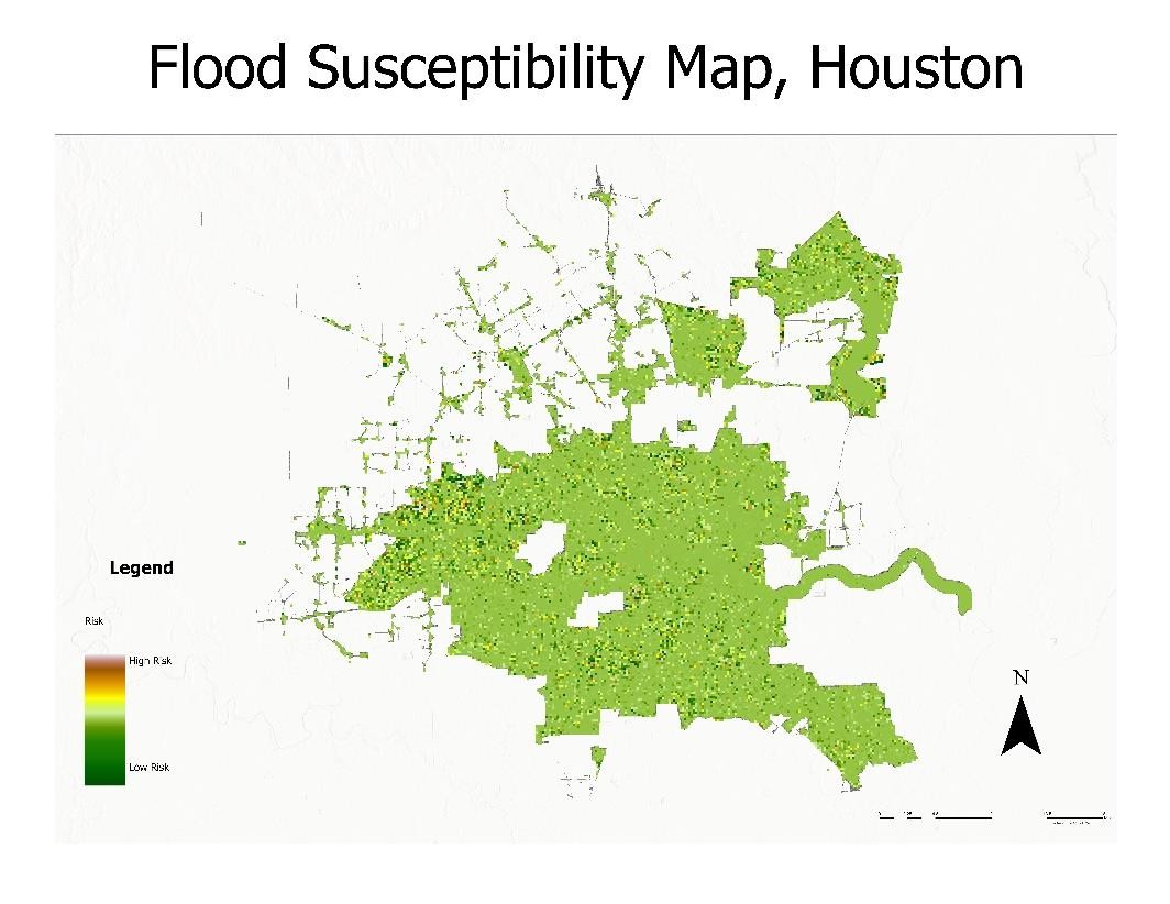
Predicting Flood Susceptibility Using Remote Sensing Data and Machine Learning

A flood susceptibility map of Houston produced with a random forest model and multi-source remote sensing data, trained on 2019 flood events and validated on 2021 floods.

Random ForestGoogle Earth EnginePythonRemote SensingFlood Risk
🎓 Texas State UniversityView details →
View project →
Completed

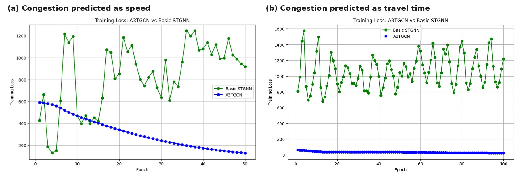
Predicting Traffic Congestion from Crash Patterns in Austin, Texas, Using Spatio-Temporal Graph Neural Networks

A spatio-temporal graph neural network approach to forecasting traffic congestion in Austin that integrates Bluetooth travel-sensor data with crash records.

Graph Neural NetworksA3TGCNPyTorch GeometricTraffic ForecastingCrash Data
🎓 Texas State University · Team project with Anupa Bhatta and Sadia Islam RituView details →
View project →
Completed

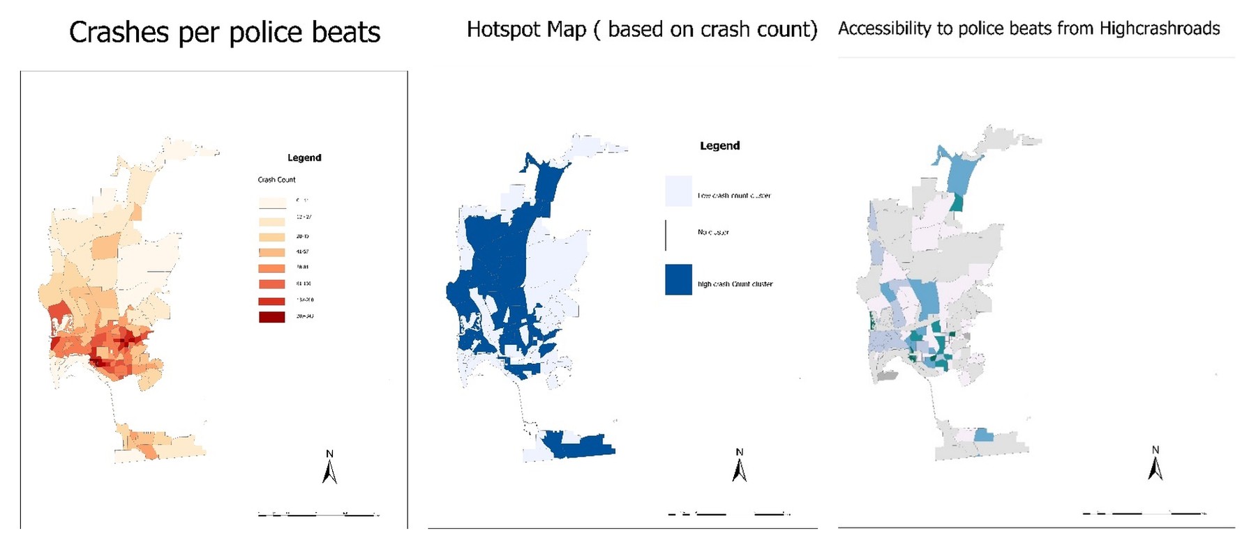
Spatial Analysis of Traffic Crashes and Police Accessibility in San Diego Using PostgreSQL

An analysis of where traffic crashes concentrate in San Diego and how accessible police beats are from high-crash roads, carried out in PostgreSQL with PostGIS and pgRouting.

PostgreSQLPostGISpgRoutingSQLHotspot AnalysisAccessibility
🎓 Texas State UniversityView details →
View project →
Completed

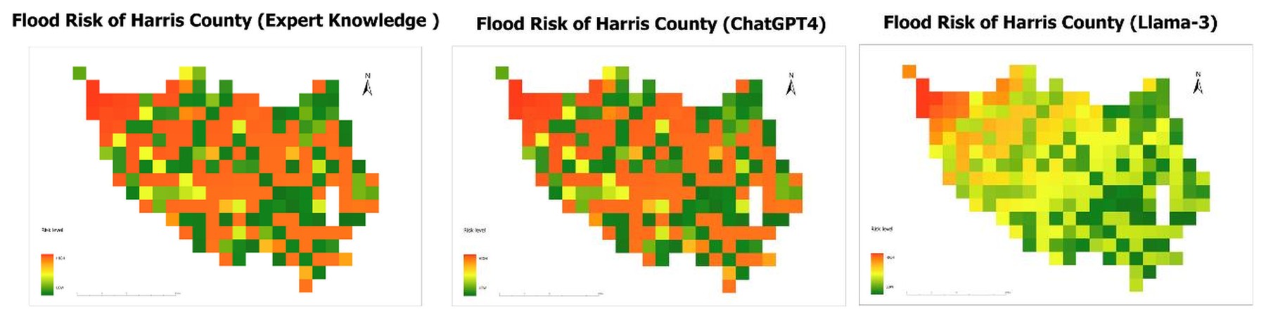
Large Language Models vs. Human Expert Knowledge: An AHP Analysis of Flood Risk in Harris County, TX

An exploration of whether large language models can support expert judgment in GIS-based multi-criteria flood risk assessment, comparing AHP weights from a human expert and four LLMs for Harris County, Texas.

AHPLarge Language ModelsMulti-Criteria AnalysisFlood RiskGIS
🎓 Texas State UniversityView details →
View project →
Completed

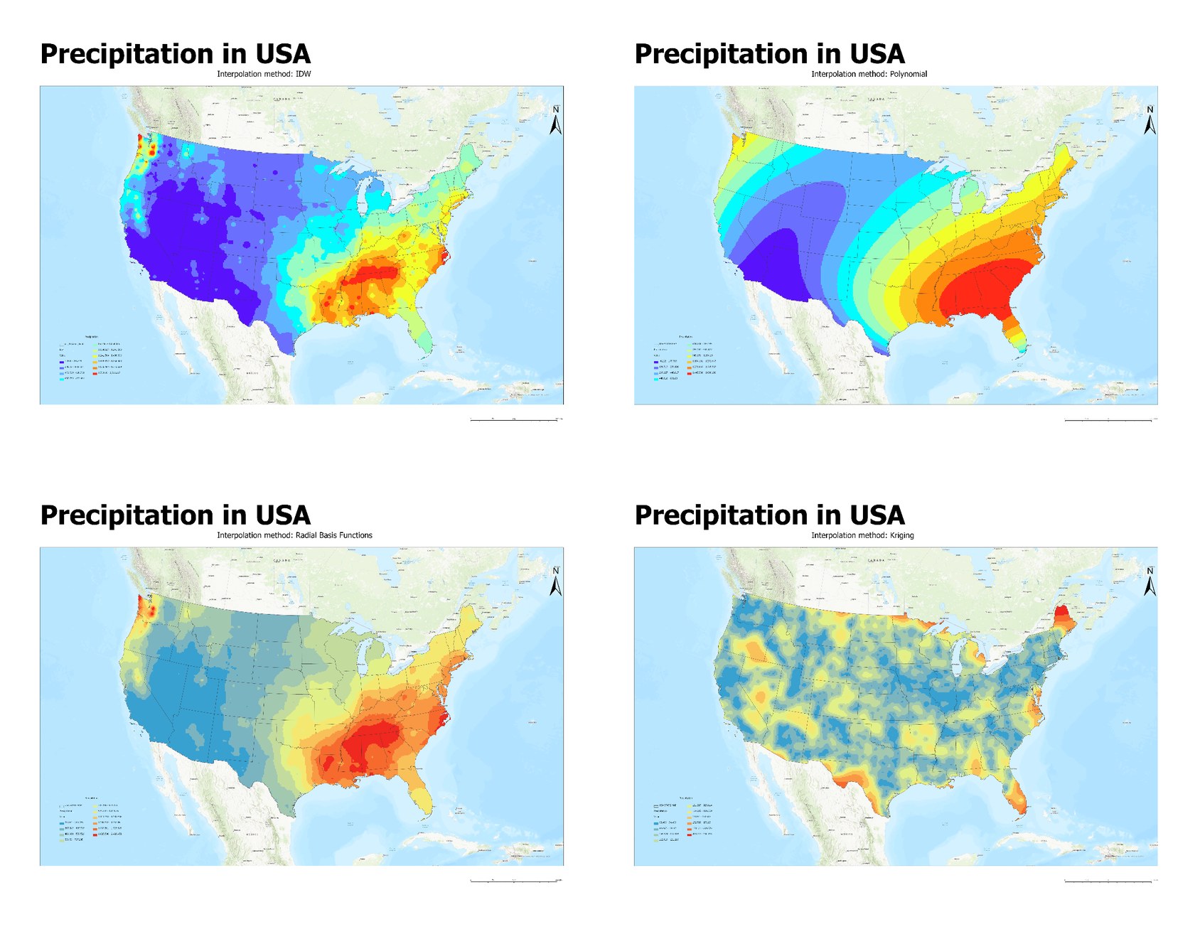
Comparing Spatial Interpolation Methods for U.S. Precipitation and Wind

A comparison of four spatial interpolation methods for mapping U.S. precipitation, together with a vector-based approach to interpolating wind direction.

Spatial InterpolationIDWKrigingGeostatisticsArcGIS Pro
🎓 Texas State UniversityView details →
View project →
Completed

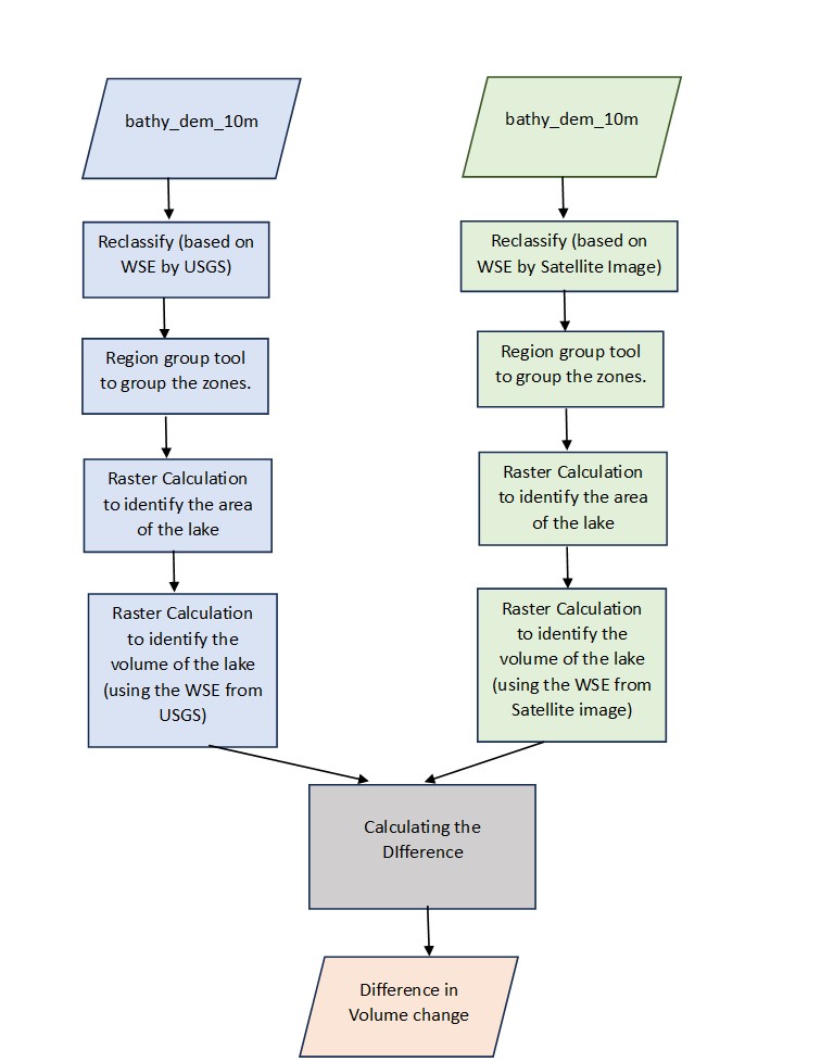
Raster Modeling of Lake Volume: Crater Lake, Oregon

A raster-based model of Crater Lake’s surface area and water volume from a bathymetric elevation model, comparing results from a USGS water surface elevation with an estimate from satellite imagery.

Raster AnalysisBathymetryMap AlgebraArcGIS ProHydrology
🎓 Texas State UniversityView details →

Publications & Presentations

  • Journal article · 2024
    Ibukun, O., Oluwafemi, O., Babatunde, O., Ibrahim, F. B., Danjuma, Y., & Mela, S. L. (2024). Evaluation of COVID-19 Cases and Vaccinations in the State of Georgia, United States: A Spatial Perspective. Journal of Geographic Information System, 16, 167–182.
    doi:10.4236/jgis.2024.163011 ↗
  • Journal article · 2020
    Ibrahim, F. B., Rahman, M. M., & Rezwana, N. (2020). Non-response to Early Warning: A Comparative Study of Three Recent Cyclones in Bangladesh. The Dhaka University Journal of Earth and Environmental Sciences, 8(1), 53–60.
    doi:10.3329/dujees.v8i1.50758 ↗
  • Poster · 2023
    Spatial Clustering Pattern of Wildfire Burning Risk in California, USA. The Southwest Division of the American Association of Geographers (SWAAG) Conference.
  • Poster (virtual) · 2023
    Spatial Clustering Pattern of Wildfires in California, USA. American Geophysical Union (AGU) Conference.
    doi:10.22541/essoar.171781177.75783529/v1 ↗
  • Poster · 2019
    2019 Dengue Disease Outbreak in Dhaka City: Scope for Prediction Using Modelling. DRR Exposure 2019, Bangladesh.

Honors & Awards

Graduate College Retention Scholarship (Summer)Texas State University
2026
Graduate College ScholarshipTexas State University
2026
National Science and Technology FellowshipRepublic of Bangladesh
2019–20
Duke of Edinburgh International AwardBronze Level
Nov 26, 2017
Youth Campaign for Earthquake PreparednessOrganized by UNDP
2016

Training

⚡
High-Performance Computing (HPC) WorkshopTexas State University, supported by NSF ExpandAI — HPC systems, SLURM job scheduling, parallel and distributed computing, GPU partitioning, and AI-focused large-scale data processing on the LEAP 2 cluster.
Summer 2025
📊
Big Data and Infectious Disease EpidemiologyPlanning, Monitoring and Research, DGHS; supported by Harvard T.H. Chan School of Public Health and a2i.
Sep 9–11, 2019
🌐
HAZUS (non-certified)Disaster & Climate Resilience Club, University of Dhaka.
Jan 13, 2018
🔥
Fire Safety and Protection Measures (non-certified)University of Dhaka and Fire Service and Civil Defense, Bangladesh.
Jul 2017

Technical Skills

GIS & Remote Sensing

ArcGISQGISGoogle Earth Engine ERDAS IMAGINESentinel Toolbox 1, 2, 3 ILWISRClimdex

Programming

PythonRSQL

Statistics & Spatial Analysis

SPSSGeoDa

Other

Microsoft Office Suite

Affiliations

Student Board MemberAGX2024 – 2026
SecretarySupporting Women in Geography (SWIG), Texas State University2025
TreasurerSOGIS, Texas State University2025
Communications OfficerSOGIS, Texas State University2024
Community OrganizerGrad Forum, Texas State University2024
Student MemberAmerican Association of Geographers (AAG)2023 – present
Student MemberAmerican Geophysical Union (AGU)2022 – 2025

Let's connect ✨

I'm happy to talk about research collaborations, GIS and remote sensing work, or opportunities in disaster and transportation geospatial science.